Lake Agnes Tea House Trail Map
Personal Work ·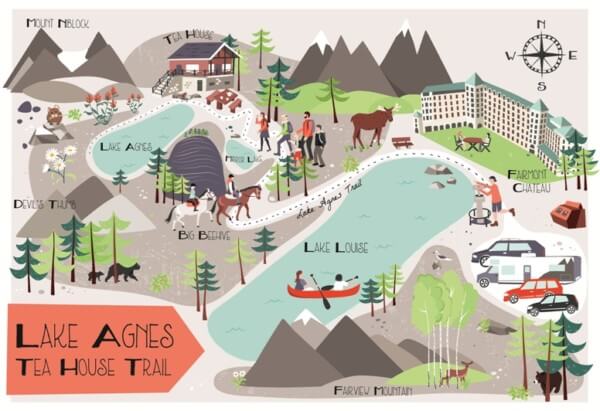
This is a recent personal project, an illustrated map showing the Lake Agnes Tea House Trail near Lake Louise in the Canadian Rockies. I drew this map as a surprise anniversary gift for my husband and to commemorate one of my favourite days of our holiday to Canada last summer. I wanted the map to be very personal to us as a family, so I included lots of detail in from that day's hiking such as the horse-riders we saw on the trail to many of the plants and animals we saw. You can also see the five of us in the map, just getting close to the Tea House and our camper van in the car park.

Bek Cruddace
Illustratorbekcruddace.co.uk
Hampshire, United Kingdom
English
I specialise in designing illustrated maps in a unique and hand-drawn style.
I have a working background in mapping and cartography and since graduating from UCL in 1998 I've worked in both academia and private consultancy before moving into professional independent design in 2011.
I am based in North Hampshire, UK but I'm experienced in working with a variety of different clients from around the UK/Globe in the editorial, publishing, advertising, corporate, tourist & charity sectors.
Clients: The National Trust, Guardian Travel, Lands End Clothing, World Of Cruising Magazine, Oliver Burns, Aa Publishing, Atlanta Magazine, The Balmoral Estate, Londonist, Canal & River Trust, Port Lympne Wildlife Reserve, Tesco Magazine, Adnams Southwold, France Today, Abta Magazine, Foundation For International Education, Discover Britain Magazine, Scottsdale Cvb, Baker Publishing Group, Propeller Design Agency For Uk Power Networks
Skills
Software: Adobe Illustrator
Associations: Association of Illustrators

United Kingdom
I specialise in designing illustrated maps in a unique and hand-drawn style. I have a...